Operational meteorologists track middle latitude disturbances in the middle to upper tropospheric flow as part of their analysis of the atmosphere. The purpose of this web page is to describe these patterns in a qualitative sense without regard to the dynamic approximations that have been developed to explain these wave motions, and to identify these features in actual atmospheric flow patterns. Upon completion of this module you will be able to:
Atmospheric flow in the middle latitudes is mainly westerly. That is, the winds have a prevailing westerly component with numerous north and south meanders that impose wave-like undulations upon the basic west-to-east flow. This flow extends from the Subtropical High Pressure zone poleward to around 65 degrees latitude. A glance at any upper level chart from 700 mb upward to 200 mb shows that the westerlies dominates the middle and upper troposphere. The term westerlies, as used on this web page, refers to this layer unless otherwise specified. For a more complete description of the mean structure and flow patterns of the mid-latitudes westerlies, see Palmén and Newton (1969, Chapter 3), among others.
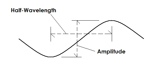
| Wave terminology can be used to describe the flow patterns in the westerlies. The schematic at the left simulates a wave extending east-west (left to right as shown) along a latitude circle. The amplitude of a wave is the north-south distance from the bottom of the trough to the top of the ridge. The wavelength is the east-west distance from a trough to an adjacent trough or from a ridge to an adjacent ridge. A "half-wavelength" is shown on the schematic. If you express a wave in a strict mathematical sense, e.g., as a sine wave, the amplitude in the mathematical expression is one-half of the amplitude shown at the right. |
 |
This image below shows a 500 mb chart for the Northern Hemisphere. The contours represent the topography of the 500 mb pressure surface, identifying valley/trough and ridge areas. When interpreted in terms of geostrophic/gradient flow, the contours show a westerly current that meanders between 35 degrees and 65 degrees north latitude.
If you plotted the height pattern along a latitude circle you would see a series of waves of varying amplitude and wavelength. These features can be described as follows:
Using these defintions, a trough (red line) can be seen running from a low center over Hudson Bay, southward to the Dakotas. A ridge (blue line) extends from the high center just west of Washington State, northward into the Yukon.
 |
| Hemispheric 500 mb Chart |
Meteorologists routinely identify and track the movement of waves in the westerlies. Waves are associated with areas of convergence and divergence in the upper troposphere, impact the intensity of surface weather systems, and, as a result, produce clouds, precpitation or clear skies. In general, troughs are sources of upward vertical motion, clouds and precipitation, while ridges are drier with less cloud cover.
Experience has shown that waves in the middle and upper tropospheric flow can be divided into two main categories: long waves and short waves, depending upon wavelength.
Wavelength is measured in an east-west direction along a latitude circle and referenced in terms of wave number. Wave number describes the number of complete waves that are found around the latitude circle. For example, wave 1 has one trough and one ridge around a latitude circle or a wavelength of 360 degrees of longitude; wave 2 has two troughs and two ridges around a latitude circle or a wavelength of 180 degrees of longitude; wave 3 has three troughs and three ridges around a latitude circle or a wavelength of 120 degrees of longitude; etc.
Long Waves
Long waves have a wave number of 1 through 6. This indicates that the shortest wavelength for a long wave is 60 degrees of longitude or the distance from Honolulu to Kansas City. In other words, a wave with a wave number of 6 would have a ridge around Hawaii and its next ridge around Missouri. Long waves are also known of major waves or planetary waves.
Long waves are characterized by cold troughs and warm ridges. On most occasions there are from 3 to 6 long waves around the hemisphere. Long waves are slow moving and often stationary (trough and ridge movements from 0 to 15 knots), and sometimes even retrogressive, that is, they move against the westerly flow toward the west. Trough locations have a preference for the east coasts of continents while ridges prefer the west coasts (in the Northern Hemisphere winter).
Determining the number and location of the long waves is not always straight-forward. In most cases a hemispheric 300 or 500 mb chart, as in the example above, is used to indenfity long waves. Some studies indicate that a 3 to 5 day mean of the middle tropospheric flow pattern should be used to find long waves. The National Weather Service has used a composite of the first five wave numbers for a specific time to indicate long wave number and location. Personal experience has shown that a loop of at least 72 hours of time for a fairly broad area (e.g., from the middle Pacific Ocean to the middle Atlantic Ocean) can be used to observe the amplification of short waves moving through a long wave trough position.
The position of the long wave trough and long wave ridge can help anticipate the level of active weather for an area. Long wave troughs usually have a series of active short wave systems moving through the long wave pattern that create varying degrees of clouds and precipitation. Long wave ridges are usually relatively quiet compared to a long wave trough. A persistent long wave ridge is often accompanied by a period of little to no precipitation.
There is one situation which occurs in the long wave pattern that needs to be mentioned: discontinuous retrogression. When the wavelength from one long wave trough to the next one downstream becomes excessively large, the downstream trough is often replaced by a new trough that forms farther west than the position of the original downstream trough. In a loop of this situation it appears that the downstream trough suddenly shifts westward or upstream in a discontinuous manner. In reality, a new trough forms.
Rossby Waves
In the late 1930s Carl Rossby published a paper on the flow patterns in the upper troposphere. Specifically, his work calculates the behavior of the planetary waves in a uniform current in a two-dimensional, non-divergent fluid. The theoretical waves described in this paper are now known as Rossby Waves and correlate well with the long waves observed in the middle to upper troposphere. As a result you will often hear the long wave patterns in the real atmosphere referred to as Rossby waves.
Short Waves
Short waves have a wave number between seven and twenty. This indicates that the longest wavelength for a long wave is around 50 degree of longitude or the distance from New York to San Francisco. Short waves are also called minor waves.
Short waves move faster than long waves (20 to 40 knots) and in the same direction as the prevailing basic current. This latter process is sometimes referred to as being "steered" by the basic current. These waves are characterized by small amplitudes and isotherm patterns out of phase with the streamlines. When isotherms are out of phase with the streamlines thermal advection can occur which modifies the amplitude of the wave. Short waves are strongest at the 700 and 500 mb level and best identified at these levels. They often reflect the high and low pressure systems found in the sea level pressure and 850 mb height patterns.
Long waves and short waves interact with each other and cause changes in the upper flow patterns. For example, when a short wave trough moves into a long wave trough, it often amplifies and contributes to the development of surface low pressure centers. As the short wave trough moves out of the long wave trough, it typically weakens, that is loses amplitude.
Cyclone Waves
In addition to long waves and short waves, the Glossary of Meteorology (2000) defines a cyclone wave. This wave is a disturbance with a wavelength of 1000 to 4000 km, or cyclone scale. It corresponds to the migratory low and high pressure systems that dominate middle latitude weather. This wavelength range is the same as that of short waves.
The Chart Above
The actual middle to upper troposphereic flow is a combination of waves of varying wavelength. This can be seen in the 500 mb chart above. On this chart there appear to be four long waves around the hemisphere (wave number 4). There are long wave troughs over the eastern United States, Europe, Central Russia, and the central Pacific Ocean. The long wave trough over Central Russia is rather broad while the one over Europe is distorted by the ridge over western Russia. This example points up the difficulty of visually identifying long waves on a hemispheric chart, as was discussed above.
Superimposed on the long wave pattern as numerous short waves. Focusing on the long wave trough over the eastern United States, there is a short wave trough indicated by the red line from low center over Hudson Bar into the Dakotas. Another short wave trough is found from Indiana to Georgia, while a third trough is over Newfoundland. Each of these impulses is being steered by the long wave trough. Can you find other short waves troughs around the hemisphere?
Closed circulations are often found at 500 mb and show up on 500 mb charts as a closed contour system. Two terms are used to describe these types of circulations: closed contour systems; and cut-off systems.
Cut-Off Lows
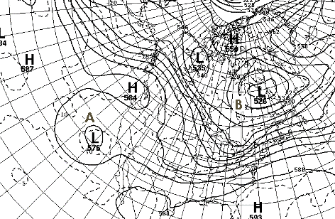 |
The chart at the left is an excellent example of a cut-off low. Low A off the California coast is equatorward of the main westerly flow that extends from the Gulf of Alaska into western Canada and then southeastward into the eastern United States. The cut-ff low is characterized by a cold core and slow movement. Cut-off lows can persist for days before being reabsorbed into the main westerly current. The areas off the Californias and in the Atlantic Ocean east of the Azores are favored regions for the formation of cut-off low centers. |
Closed Contour Lows
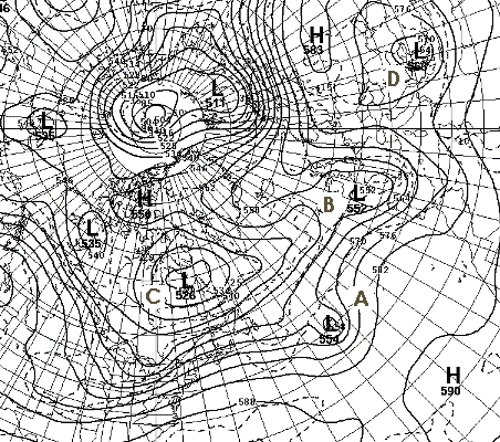
| Closed contour systems that are embedded within the westerly current are called closed contour lows. These lows move with the westerly current and the closed contour may open or remain closed as the system changes intensity. On the chart at the right Low A and Low B are examples of closed contour lows. Low C is also a closed contour low but is poleward of the main westerly current. It is associated with the long wave trough in the area. This type of low is often stationary but can migrate slowly in either an eastward or westward direction. Low D is another closed contour low that is outside the main westerly flow. However, due to its location along a secondary track in the westerly flow, it is not classified as a cut-off low. |
 |
Blocking
A special category within the broader class of closed circulations is the blocking high or blocking anticyclone. This high center is warm core, is fairly large in extent, and remains nearly stationary for a week or more. It obstructs the normal west-to-east progression of the middle and upper tropospheric waves. The flow around this high has a significant meridional component and often takes the shape of the Greek letter omega. As a result blocking highs are often referred to as omega highs.
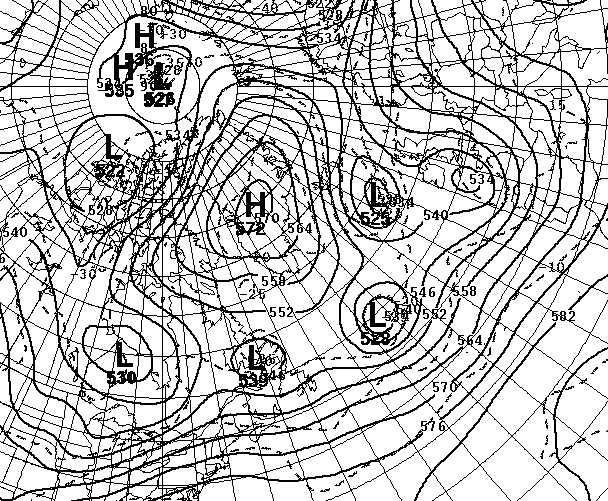
| Prolonged blocking tends to occur during the Spring over the eastern portions of the North Atlantic Ocean or over the eastern North Pacific region. The high is usually centered on the northern edge of the middle latitudes. Closed contour lows are frequently found equatorward of the omega block. The 500 mb chart at the right shows a blocking high pressure center over Greenland. The omega shape is clearly visible. A series of closed contour lows is seen to the south of the block. These low centers are moving eastward across the North Atlantic Ocean from Labrador to the British Isles. In this case the block has stymied the general eastward progression of the long waves but as the high persisted, a secondary track established itself across the central North Atlantic. |
 |
Split Westerly Currents
Most of the time there is one broad westerly current present in the middle to upper troposphere. This type of pattern is seen on the 500 mb chart above over the Pacific Ocean eastward into the United States. There are times, however, when the westerly current splits into two streams. This type of pattern can be seen over Europe on the 500 mb chart above where the main westerly band flows across the British Isles into Scandanavia while a secondary currents extends across the Mediterranean Sea. A strong (high amplitude) ridge is usually found on the poleward side of the secondary flow.
Zonal versus Meridional Flow
The terms zonal flow and meridional flow are often used to give a general description of the middle latitude westerlies. Zonal flow is middle to upper tropospheric flow that is mainly westerly with a small meridional component. Contrast this to meridional flow in which the north-south component is unusually pronounced. These terms should be applied to broad regions on the scale of the 48-contiguous United States or larger, and not to smaller regions.
The Jet Stream
Due to the pole-to-equator temperature differences, a band of high speed winds is found in the upper troposphere within the broad middle latitude westerlies. This band of high speed winds is called the jet stream. Let's quote the World Meterorology Organization (WMO) glossary to define a series of terms associated with the jet stream.
As you can see from these definitions, the jet stream refers to the broad band of high speed westerlies typically found in middle latitudes. The wind speed should be at least 50 knots for a band of winds to be considered a jet stream. The jet stream winds are stronger in winter, reaching speeds in excess of 150 knots, and weaker in summer. The core is not restricted to one pressure level but meanders upward and downward in the upper troposphere, depending upon the overall flow pattern.
Within the broad high speed band are jet maxima, often referred to as jet streaks. These streaks are important because areas of convergence and divergence, and associated vertical motion, are found near these speed centers. Intensifying low pressure centers and the occurrence of thunderstorms are frequently associated with jet streaks. Details on these relationships is beyond the scope of this web page.
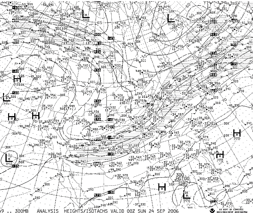
The 300 mb chart above shows two jet axes as shaded/hatched areas. One extends from New Mexico northeast to Chicago then east to Maine. A jet streak is located just north of Vermont. A second jet axis and jet streak is located over western Canada. Note that these jet axes are located in the tight gradient of the 300 mb contour pattern.
The best way to become familiar with the long and short wave patterns in the westerlies is to examine upper tropospheric charts on a daily basis. Use day-to-day comparisons and loops to watch the movement of the short waves and the changes in the long wave pattern. Compare what you see with the features and patterns described above. Correlate cloud and weather patterns with the upper level waves. Note that significant weather is typically located between a trough and its downstream ridge. Experience is often the best teacher for learning how the atmosphere works.
The following references provided defintions for this web page:
Glickman, Todd S., 2000: Glossary of Meteorology. American Meteorological Society, Boston, 855 pages.
World Meteorological Organization, 1992: International Meteorological Vocabulary. WMO, Geneva, 784 pages.
The following references provide brief discussions of long wave patterns:
Palmén, E., and C.W. Newton, 1969: Atmospheric Circulation Systems, Their Structure and Physical Interpretation. Academic Press, New York, 603 pages. [Section 6.4]
Petterssen, Sverre, 1956: Weather Analysis and Forecasting. Volume I: Motion and Motion Systems. McGraw-Hill, New York, 428 pp. [Section 10.1]
Reiter, Elmar, 1961: Jet-Stream Meteorology. University of Chicago Press, Chicago, 815 pp. [Section 8.32]
Saucier, Walter J., 1955: Principles of Meteorological Analysis. University of Chicago Press, Chicago, 438 pp. [Chapter 11]