 |
| Vertical Temperature Structure Ice Pellets (left) - Freezing Rain (right) |
Upon completion of this web page you will be able to:
One of the most dangerous types of winter weather is freezing rain. The coating of ice it produces makes travel hazardous and causes power lines to collapse. The Glossary of Meteorology defines freezing rain and ice pellets (more commonly known as sleet) as follows:
| Freezing Rain |
|
rain that falls in liquid form but freezes upon impact to form a coating of glaze upon the ground and on exposed objects; this implies that the surface temperature is 32 degrees Fahrenheit or less |
| Ice Pellets |
|
transparent or translucent pellets of ice, 5 mm or less in diameter |
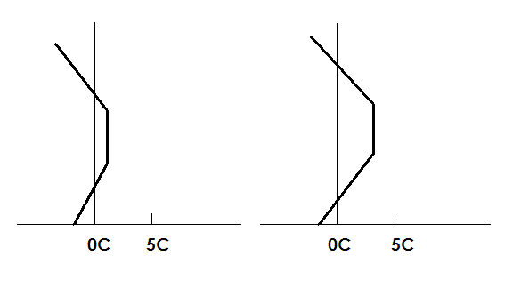
The vertical temperature structure in the lowest 10,000 feet of the atmosphere determines whether freezing rain or ice pellets occur. In both situations, the vertical structure is similar: a sub-freezing layer near the Earth's surface is overlayed by an elevated above-freezing layer. This basic structure is shown below.
|
| Vertical Temperature Structure Ice Pellets (left) - Freezing Rain (right) |
For freezing rain, assume that the precipitation forms as snow and then falls into warm (above-freezing) layer. By the time the precipitation reaches the base of the warm layer, it is completely melted and falls into the cold (below-freezing) layer as a liquid droplet.
In order for liquid droplets to freeze, you need freezing nucleii and temperatures generally below -10 degrees Celsius, something called heterogeneous nucleation. Typically, at temperatures warmer than -10 degrees Celsius, the number of freezing nucleii are not sufficient to initiate the freezing process. As a result the droplets stay liquid and become supercooled. When these supercooled droplets hit something at ground level, or an aircraft above the ground, the droplets freeze and a glaze forms.
The key here is that the snow completely melts and forms the supercooled droplet.
For ice pellets or sleet, again assume that the precipitation forms as snow. When this snow falls into the warm (above-freezing) layer, the snow partially melts. By the time the precipitation reaches the base of the warm layer, it is a mixture of ice crystals surrounded by liquid water.
As the ice crystal/water mixture falls into the cold (below-freezing) layer, the ice crystal acts as a freezing nucleii and the refreezing process occurs. The result is an ice pellet or sleet.
The key here is that the snow partially melts and the refreezing occurs.
Studies of freezing rain and ice pellet situations have examined the differences between the two situations in terms of four parameters:
The strength of the cold (below-freezing) layer is measured in terms of the coldest temperature in the layer. If the temperature is less than -10 degrees Celsius and there are sufficient freezing nucleii, and given enough time for freezing to occur, either snow or sleet can form.
One study indicated that if the depth of the cold layer is greater than 2,500 feet, there is a tendency for snow or ice pellets to form. If the depth of the cold layer is less than 2,500 feet, there is a tendency for freezing rain to form. This study did not take into consideration the amount of melting that takes place in the warm layer (as described above). As a result, use the depth of the cold layer as a secondary evaluation factor.
Modeling studies evaluated the amount of melting that occurs based upon the strength or maximum temperature in the elevated warm layer. The results of this study were as follows:
The diagrams above illustrate the difference in the strength of the elevated warm layer.
The amount of melting in the warm layer is also a function of the depth of the warm layer. In a qualitative sense, the deeper the warm layer, the more time available to melt snow to rain. Similarly, the thinner the warm layer, the less time available to melt snow to rain. No specific numbers are available to quantify this factor.
Freezing rain and ice pellet events usually occur then warm humid air overrides cold surface air. This situation is common with a stationary fronts. North winds pump cold air into the low levels while warm south wind lift along the frontal surface and produce the elevated warm alyer. The cross-section below is taken perpendicular to such a front.
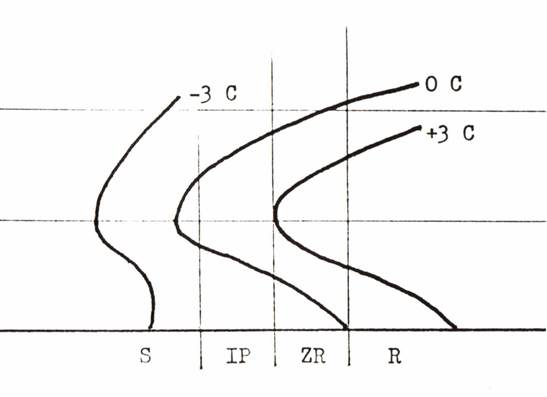 |
| Cross-Section for a Freezing Rain and Ice Pellet Event |
Highlighted on the figure above are the +3, 0 and -3 degree Celsius isotherms. The tongue of elevated warm air is obvious.
This cross-section shows the typical sequence of precipitation type as you move from the warm to cold side of the system. Precipitation starts as rain on the warm side. The rain becomes freezing rain as the surface temperature drops below 32 degrees Fahrenheit. As you move farther into the cold air, the precipitation turns to sleet and finally to snow.
Approximately 30 percent of all freezing precipitation events do not have an elevated warm layer. The majority of these cases are freezing drizzle situations. A review of ice particle formation shows that a cloudy parcel of air with a temperature between -10 and 0 degrees Celsius, with no ice crystals present, and no large droplets, is unlikely to form ice. Instead, small supercooled liquid droplets tend to form, that is, drizzle.
One study found that sounding associated with freezing drizzle were characterized by:
It is important that there are no higher cloud layers above the surface cloud layer. If there is a higher cloud layer, it can drop ice crystals into the lower layer. These crystals would act as freezing nucleii and produce snow instead of freezing drizzle. An example of this type of sounding is shown below.
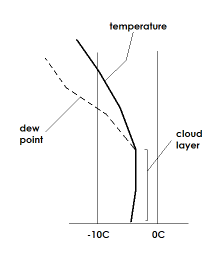 |
| A Typical Freezing Drizzle Sounding |
Freezing rain and ice pellets produce some of winter's worst weather. It is important for a forecaster to know how these precipitation types form, understand the physical processes that are occurring, and be able to apply this knowledge to the forecast process. The basics for freezing rain and ice pellets have been presented in this lesson. Use this information wisely and you should have a good handle on the short-term changes in these types of situations.
Instructions: Place the cursor over the answer of your choice. If you are correct, it will be highlighted in green; if you are incorrect, it will be highlighted in red.
The vertical temperature structure associated with freezing rain and ice pellets is characterized by:
In freezing rain situations, the snow entering the top of the warm layer:
If the temperature in the elevated warm layer is +2 degrees Celsius, the most likely form of precipitation is:
As you move from the cold side of a front to the warm side, the sequence of precipitation type is most likely to be:
Soundings associated with freezing drizzle are characterized by: