 |
| 250 mb Isotach Analysis for the Northern Hemisphere image from NOAA/Earth System Laboratory |
Late in World War II high flying bombers on missions over Japan and Germany ran into very strong head winds. These winds were often in excess of 200 miles an hour and planes occasionally found themselves stationary over their target area. These encounters were the first observations of the jet stream. Considerable work during the late 1940s and 1950s expanded our knowledge of the jet stream both theoretically and observationally. The purpose of this web page is to explore some of this discoveries and outline aspects of the jet stream that are important to operational forecasters.
The term "jet stream" can be used to refer to any concentrated area of high wind speed. In practice, however, the term is typically limited to the high speed winds in the upper troposphere. The terminology below combines definitions from the World Meteorological Organization (WMO) and American Meteorological Society (AMS) into the descriptions used for this web page.
The mid-latitude jet stream is a quasi-horizontal band of high speed air in the upper troposphere. It is typically thousands of kilometers in length, hundreds of kilometers in width, and several kilometer deep. It is essentially a flat tubular feature that meanders through the upper portions of the troposphere.
Jet stream isotach analyses usually start at 50 knots or 30 meters/second, depending upon your analysis preference. Maximum wind speeds in jet streaks are typically in the 100 to 200 knot range. Wind speed as high as 300 knots have been observed and 300 knots is considered an approximate upper limit on jet streak speeds.
Strong vertical and horizontal wind shears are found along the jet stream, particularly near jet streaks. Vertical wind shear values are on the order of 5-10 m/s/km while horizontal wind shears are on the order of 5 m/s/100 km. There is cyclonic wind shear on the left side of the jet axis (looking downstream) and anticyclonic wind shear on the right side of the jet axis.
Although the term "jet stream axis" was defined in the previous section, the axis itself is usually not drawn on isotach analyses. Nevertheless, if you want to assess jet streak quadrants (discussed below) or wind shear, it is useful to add this feature to the typical computer isotach analysis.
|
| 250 mb Isotach Analysis for the Northern Hemisphere image from NOAA/Earth System Laboratory |
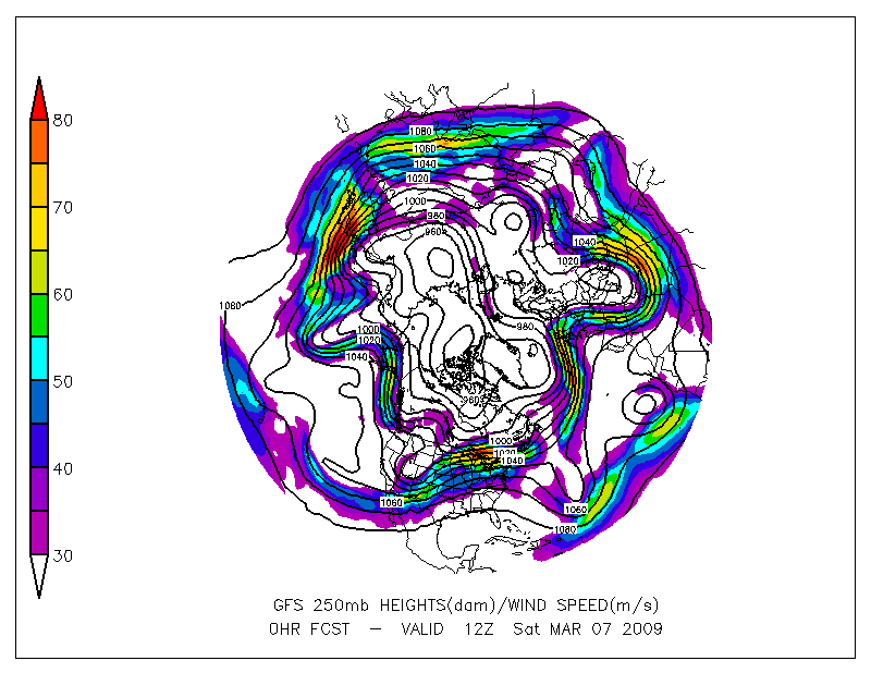
The image above shows a hemispheric isotach analysis on a typical winter day. You can see a band of 30 m/s or higher winds in the mid-latitudes extending around the Northern Hemisphere. Several jet streaks of at least 60 m/s are visible.
There are two primary jet streams in the mid-latitude troposphere: the polar-front jet stream (PFJ) and the subtropical jet stream (STJ). Let's look at each of these jet streams.
The polar-front jet stream is typically strongest around 300 mb (9 km) but can usually be identified on both the 300 mb and 250 mb charts. For a very strong jet streak, an isotach maximum can often be seen at the 500 mb level, particularly during winter.
The core of this jet stream (in the sense of definition (b) above) meanders vertically. Thus, to get a true picture of the level of maximum wind, you need to examine a vertical profile of wind speed or a cross section across the flow.
The polar-front jet stream is associated with the polar front and located over the frontal or baroclinic zone found with this front. This baroclinic zone extends through the depth of the troposphere below the jet core.
As seen in the image above, the polar front jet stream extends around the hemisphere. Using the words of Reiter (1961), it "should not be regarded as continuous in its longitudinal extent, but rather as a zone which constantly migrates, dissipates, and then re-forms elsewhere.�
The subtropical jet stream is located equatorward of the PFJ in the 20o to 30o latitude band, and higher in the troposphere in the 250 to 200 mb layer. It is best identified on the 200 mb chart and can be seen on the 250 mb chart. It is usually not visible in the isotach pattern below the 400 mb level.
The figure below shows the relationship of both the polar front jet and the subtropical jet stream to the tropopause. The core of both jets is located just below the tropopause and on the equator side of the tropopause break (or tropopause fold).
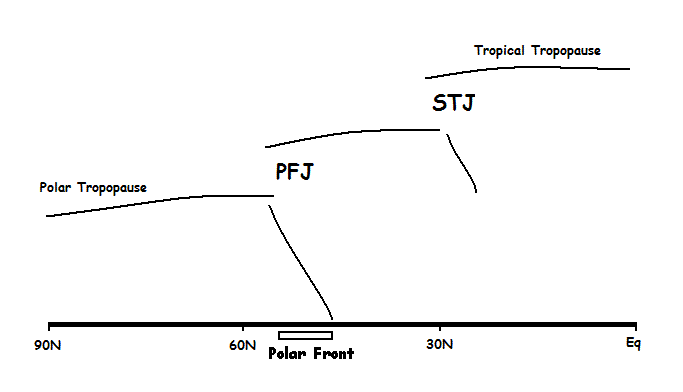 |
| North-south cross section showing the location of the core of the polar front jet stream (PFJ) and subtropical jet stream (STJ) vertical axis not to scale |
On occasion the subtropical jet stream will move poleward and be found within several degrees of latitudes of the polar front jet. When the PFJ moves southward across the United States and the STJ moves northward, the two can merge to the point where it is difficult to distinguish the two.
The baroclinic zone associated with the STJ is shallow compared to the PFJ and limited to the upper troposphere. This jet is strongest, on average, off the Asian coast, and is found across the southern United States, the Mediterranean and Middle East, and from India into China and Japan. In the hemispheric image above, the subtropical jet stream can be seen across New Mexico into the Texas panhandle.
An analysis model is an idealized representation of a weather system that helps you as a meteorologist visualize that system, its associated weather, and evolution. In the case of the jet stream, the analysis model shown below is limited to the general isotachs pattern around a jet streak.
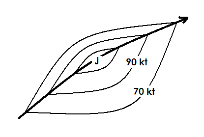 |
| Jet Stream Analysis Model (No.Hem.) |
The bold line with the arrow head represents the jet stream axis or line of maximum wind speed. The isotach gradient on the right side of the axis (looking downstream) is weaker than the gradient on the left. This means that the horizontal wind shear is typically greater on the left side of the jet axis than it is on the right. This is due to the fact that stability considerations limit the lateral shear on the right side of the flow.
An analysis model serves as an idealization for the analyst who is constructing isotachs to identify the jet streak location. The idea is to fit the observations to the model as closely as possible. Where there is an abundance of data, isotachs are drawn to the data. However, if there is a lack of data, the model helps fill in the gaps. Essentially, when you finish your analysis it should look similar to the idealization.
Most upper air analyses these days are done by computers using either a weighted interpolation scheme or some type of statistical analaysis routine. Computer analyses tend to weakens gradients. As a result, gradients shown on computer analyses may not match the jet stream analysis model shown above. Also, computer analyses do not draw a jet axis or kink isotachs at the axis line.
The following steps are suggested for constructing a jet stream analysis via hand analysis:
You can annotate hard copies of computer analysis to indicate the location of the jet stream axis. If the computer analysis includes observations or grid wind barbs, the ideas outlined for hand analysis can be applied. If no data are shown or if you are working with a prog chart, the following guidelines are offered:
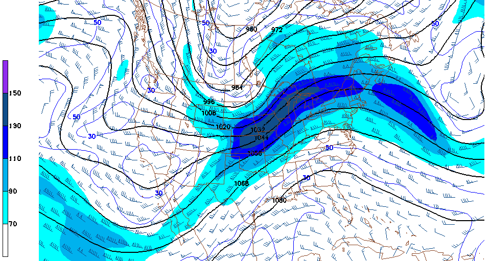 |
| 250 mb Isotach Analysis (GFS model) |
On the 250 mb chart above there is a jet streak that extends from Kansas into the Great Lakes. The eastward extension of the jet continues across Maine to another weaker jet streak south of Nova Scotia. Placement of a jet axis from central Iowa across southern Quebec into Atlantic Ocean is fairly straightforward.
The jet axis upstream from Iowa is more complex. One branch of the jet axis extends westward across Wyoming into western Montana while another branch goes southwest into eastern New Mexico and Baja.
The two branches and the breadth of the maximum over Kansas-Nebraska-Iowa suggest the possibility of a polar-front jet stream adjacent to a subtropical jet stream. The subtropical jet stream could extend from the New Mexico branch across northeastern Kansas into southeastern Iowa. The polar-front jet stream follows the branch through Wyoming across southeastern Nebraska into central Iowa before continuing northeastward. Examining the corresponding isotach analyses at 300 mb and 200 mb will likely clarify the double jet structure.
The jet stream is a major component of the mid-latitude flow. It is a source of kinetic energy, impacts the genesis and intensification of surface cyclones, influences thunderstorm development, affects synoptic scale vertical motion in the troposphere, and causes changes in the amplitude of upper tropospheric waves. Let's look at the latter two of these topics.
The area around a jet streak can be divided into four quadrant relative to the location of the jet maximum along the jet axis. The terms left and right are used to denote the area to the left and right of the axis, respectively, looking downstream. As a result of the air flowing through the area of maximum wind speed faster than the maximum itself moves, the area upstream from the maximum is called the entrance region and the area downstream from the maximum is called the exit region.
Combining these two designation, the fours regions around a jet streak are termed: left entrance region, the right entrance region, the left exit region, and the right exit region. The entrance region is sometimes referred to as the rear area and the exit region is called the front area. Use of these terms yields: the left front quadrant, the right front quadrant, the left rear quadrant, and the right rear quadrant.
It can be shown dynamically, that for straight flow in the upper troposphere, the left front and right rear quadrants are areas of divergence while the right front and left rear quadrants are areas of convergence. (See upper portion of the figure below.) Areas of divergence in the upper troposphere are typically associated with upward synoptic scale vertical motion while area of upper level convergence are typically associated with downward synoptic scale vertical motion. This is reflected in the lower portion of the figure below. This combination of rising and sinking air creates a cross axis flow called ageostrophic wind shown by the small arrows on the upper portion of the figure.
If air that is at or near saturation is lifted, clouds, and possibly precipitation, will result. The practical implication of these dynamic considerations is the clouds and precipitation are most likely in the left exit and right entrance regions of a jet streak.
The four quadrant analysis is, strictly speaking, valid only for straight flow. Hence it should not be applied to curve flow without some adjustments. Specifically, for cyclonically curved flow, the dynamic implication on the left side of the axis hold, but those on the right side may not. Similarly, for anticyclonically curved flow, the dynamic implication on the right side of the axis hold, but those on the left side may not. In today's world of gridded data sets, if you want to know the upper level divergence, you can calculate it directly from the wind field. On some meteorological workstations, divergence is available at multiple levels in the troposphere.
 |
| Jet Stream Quadrants (adapted from Uccellini) |
Because cyclones need divergence in the upper troposphere to maintain themselves, and because the deep thermal gradient on the cold side of a front is located below the jet stream axis, the figure below represents the typical relationship of the surface systems to a jet streak.
 |
| Jet Stream Vorticity and Surface System Relative Location |
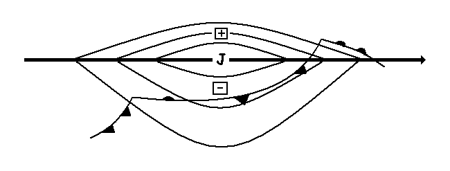
The vorticity pattern associatd with a (straight flowing) jet streak shows a strong positive relative vorticity maximum to the left of the jet maximum [shown as a plus on the figure above] and a weaker negative relative vorticity minimum to the right of the jet maximum [shown as a minus on the figure below]. On an absolute vorticity chart, there will be an elongated lobe of positive absolute vorticity on the poleward side of the axis [not shown on the figure].
The location of the vorticity maximum and minimum indicate that there should be positive vorticity advection (PVA) in the left exit and right entrance regions of a jet streak. Quasi-geostrophic theory indicated the PVA is favorable for cyclone development. Hence, the typical location of a intensifying surface low center is in the left exit region while newly formed frontal waves are common in the right entrance region.
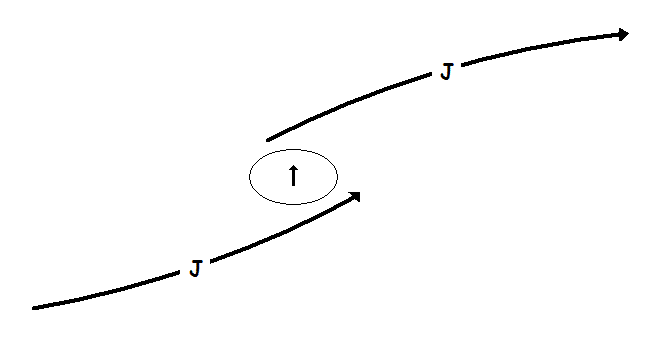
When two jet streaks approach each other, their divergent quadrants can overlap and create an area of enhanced upward vertical motion. This synoptic scale lift can produce are area of significant precipitation. The figure below shows a typical situation where the divergent quadrant of a jet streak entering a ridge (upper streak) overlaps the divergent quadrant of the jet streak coming around a trough (lower streak). The oval with the up-pointing arrow would be the area of enhanced upward motion.
 |
| Coupled Jet Streams and Area of Enhanced Upward Motion |
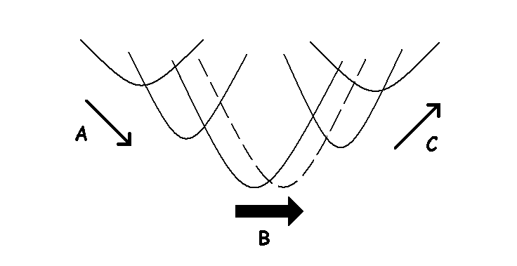
As a jet streak moves through a short wave trough, it interacts with the amplitude and movement of that trough. These changes can be explained dynamically but will only be described here and are schematically illustrated in the figure below.
 |
| Relative Position of Jet Stream to a Trough |
Three situations present themselves for short-term changes to the trough amplitude and movement:
As a jet streak moves southeastward along the back side of a trough (position A in the figure above), it tends to amplify the trough, and possibly slow the short-term trough movement.
If a jet streak is located in the base of a trough (position B in the figure above), the trough will continue its movement eastward with little change in amplitude or speed.
If a jet streak is located downstream from a trough (position C in the figure above), the trough will tend to weaken (reduce the amplitude) of the trough and move it rapidly northeast over the next 12 hours.
If you observe these patterns on the current 500 mb or 300 mb analysis, you should expect the computer progs to show changes similar to the above on the 12 hours forecast. These patterns provide you with a dynamic basis for validating the short term computer progs.
The following charts provide an example of a hand analysis of a jet stream.
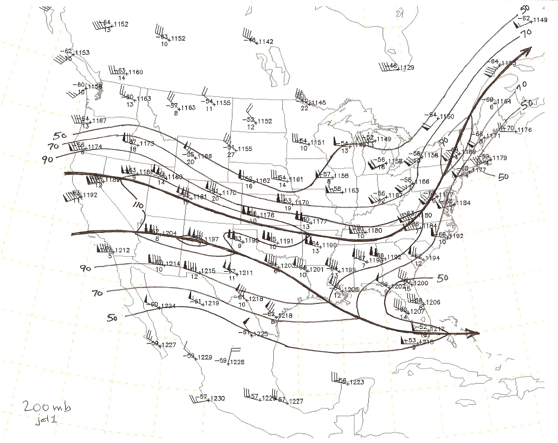 |
| 200 mb Jet Stream Analysis |
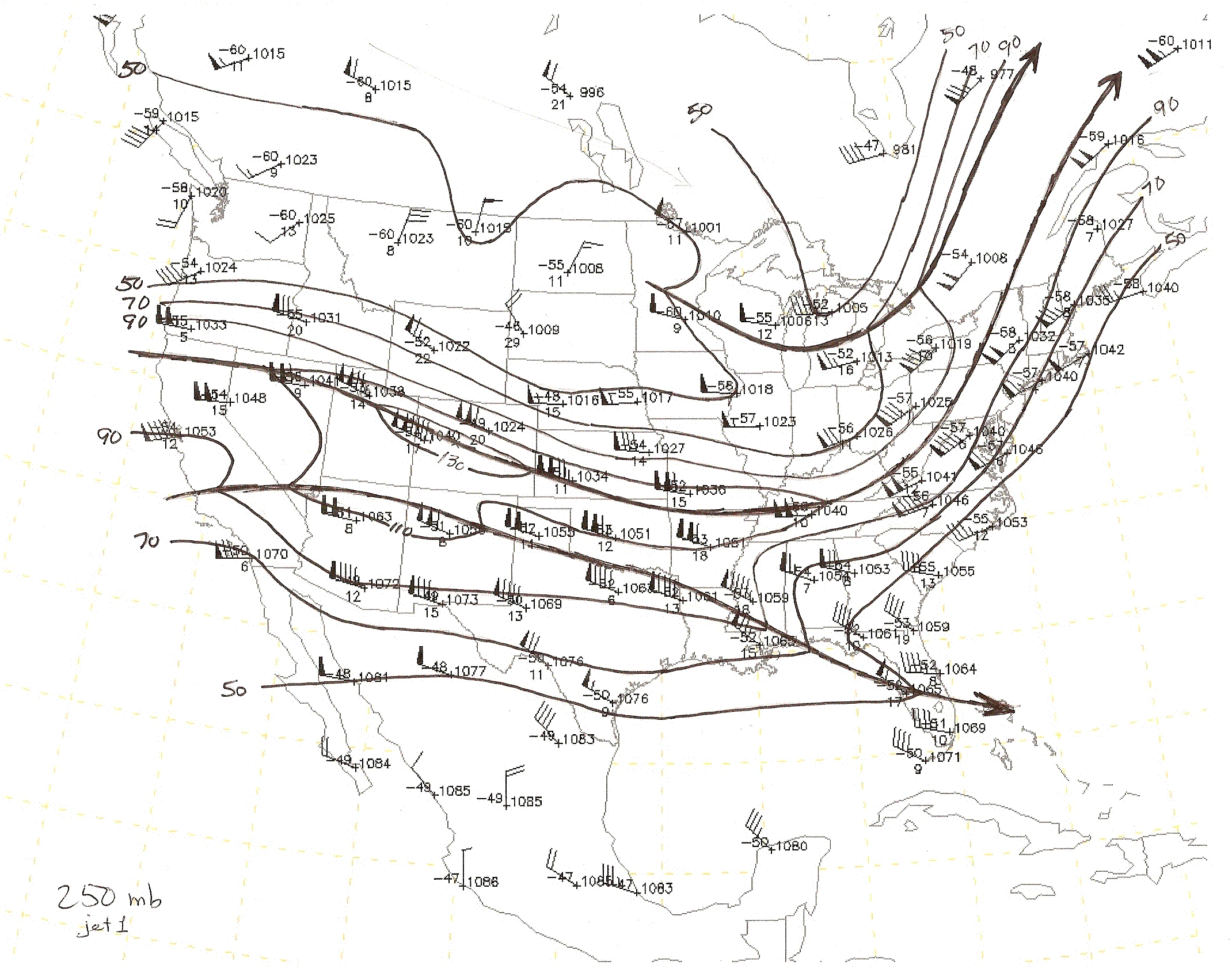 |
| 250 mb Jet Stream Analysis |
 |
| 300 mb Jet Stream Analysis |
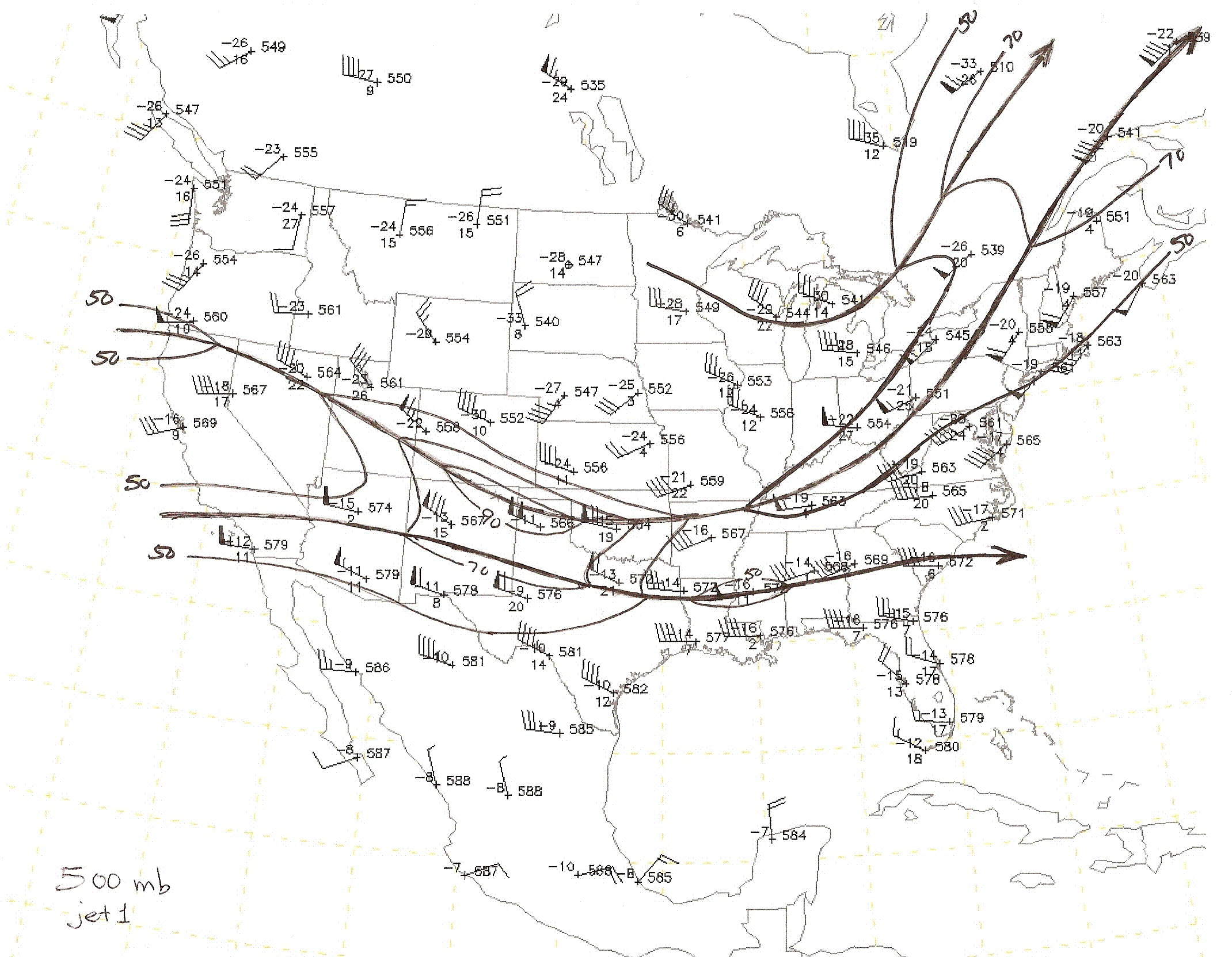 |
| 500 mb Jet Stream Analysis |
The aim of this web page is to provide an overview of those aspects of the jet stream that can be used in operational forecasting. An explanation of jet stream dynamics, except where operational application is appropriate, have not been addressed. A more complete description of the jet stream can be found in the references below.
Carson, Toby N., 1991: Mid-Latitude Weather Systems. Harper Collins Academic, 507 pp. [available from the American Meteorological Society]
Glickman, Todd S., editor, 2000: Glossary of Meteorology, 2nd ed. American Meteorological Society, 855 pp.
Palmen, E., and C.W. Newton, 1969: Atmospheric Circulation Systems, Their Structure and Physical Interpretation. Academic Press, 603 pp.
Reiter, Elma, 1961: Jet-Stream Meteorology. University of Chicago Press, 515 pp.
Shapiro, M.A., and Daniel Keyser, 1990: Fronts, Jet Streams and the Tropopause. (Article in "Extratropical Cyclones, The Erik Palmen Memorial Volume," C.W. Newton and E.O. Holopainen, editors.) American Meteorological Society. 167-191.
World Meteorological Organization, 1992: International Meteorological Vocabulary, 2nd ed. WMO/OMM/BMO - No. 182, 784 pp.